African Regions in Historical Perspective
|
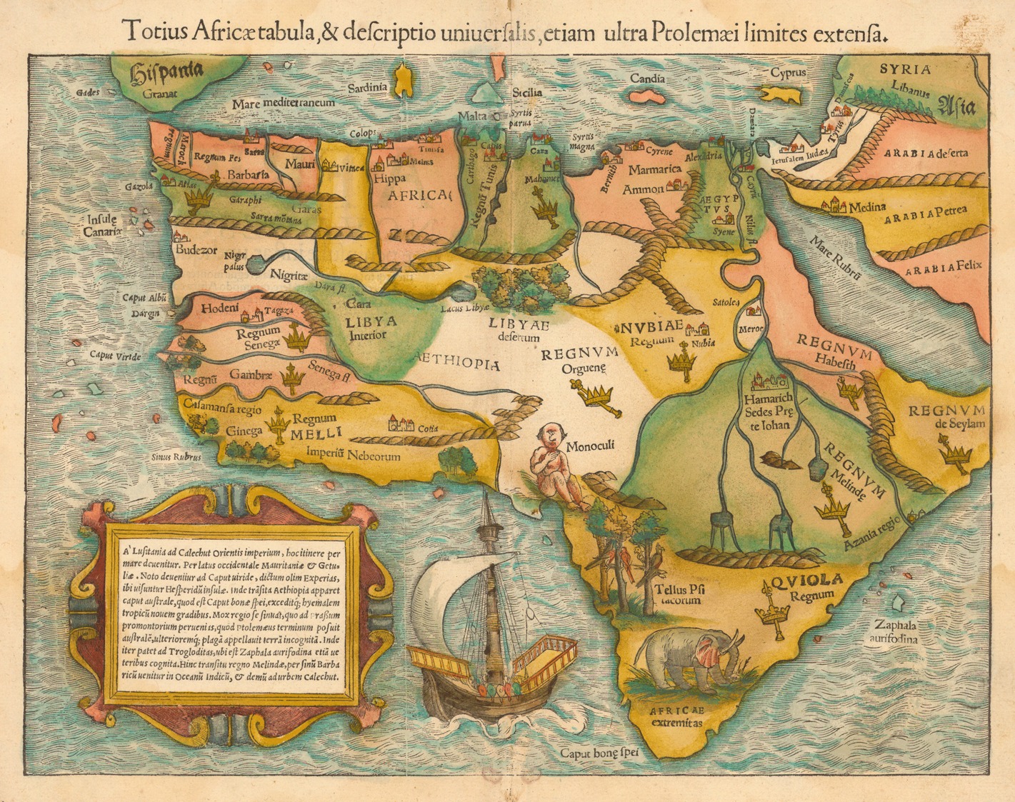
An early depiction of the entire continent, this fanciful map provided much misinformation and was made as an itinerary on how to circumnavigate Africa. Sebastian Münster, “Totius Africæ tabula & descriptio uniuersalis etiam ultra Ptolemaei limites extensa” (Basel: 1542), https://catalog.afriterra.org/map/463. |
There are many maps of Africa that illustrate geographic features, linguistic groupings, colonial landscapes, or modern countries, and beyond. This tool is directed at historical periods between circa 1500 and 1900, for which there are few inland maps other than depictions often based on incomplete or inaccurate information drawn up from hearsay and speculation. The aim here is to provide a basic geographic understanding of the continent and its peoples from perspectives rooted in African and African diaspora history.
AfricanRegions.org is helpful for researching and teaching this continent’s complex history in broad, regional terms. It centers on a geographic hierarchy that divides Africa into six broad regions that are sub-divided into 34 subregions, including major offshore islands. By definition, a region is an area or division with definable characteristics but not always fixed boundaries. Design concepts here attempt to portray fluid, fuzzy, and non-linear edges, which are difficult to represent on an interactive map. In essence, loose borders shift depending on historical contexts, interpretations, and periods.
There are various ways to map Africa. Linear boundaries unavoidably divide socio-political similarities and ethnolinguistic groupings that have fluctuated over time. The regions presented here might be contentious for some, such as people opposed to yet another socio-political map that may seem to perpetuate the fragmentation of Africa, or indeed others who consider North Africa an extension of the Middle East, or still others who might misconstrue how regionalization enhances research and teaching. Such considerations mean that drawing African regions requires constant reflection and revision.
This regionalization is created from primary sources and the scholarly literature following rigorous academic standards. They are primarily devised as a neutral guide to the continent with labels that are easy to input and translate for database construction and historical reconstruction. The intention is to avoid terms that might be confused with ethnolinguistic groups, the jargon of slave traders, colonial places, modern countries, and other perspectives. As a controlled vocabulary, regional categories can consolidate, link, and display larger datasets about people, events, and places in African and African diaspora history, which derive from archival collections, digitized primary sources, scholarly analysis, and other multimedia.
This website is meant to stimulate and facilitate discussion, debate, and inquiry about historical maps of Africa found on the internet today. For comparative and educational purposes, the regional polygons are overlaid on top of the following four base maps: elevation, vegetation, colonial boundaries, and modern-day countries. There are added layers for major landforms, lakes, and rivers, as well as equatorial lines. Although in English, this website is accessible via Google Translate in a variety of languages. For a collection of 5,000 historical maps of Africa found in primary sources, users are also encouraged to register at Afriterra: The Cartographic Free Library.
Credits
Using interdisciplinary historical and computational research methods, this resource/tool builds upon collaborative scholarship cited in the co-authored articles below. Website content, design, programming, and sustainability are based out of CU Boulder’s Digital Slavery Research Lab, under the direction of Henry Lovejoy (Associate Professor, Department of History), and in partnership with Walk With Web Inc., under the direction of Kartikay Chadha (CEO) and Maria Yala (Senior Web Developer). Karl Grossner, Technical Director and Platform Developer of the World Historical Gazetteer, donated GeoJSON data. This website has been supported through a Mellon Foundation New Directions Fellowship (NN-2006-08535) and a National Endowment for the Humanities Connections Grant (AKB-285879-22).
For more information about the dilemmas encountered during the identification of African regions and subregions, please refer to:
Henry B. Lovejoy, Paul E. Lovejoy, Walter Hawthorne, Edward A. Alpers, Mariana Candido, Matthew S. Hopper, Ghislaine Lydon, Colleen Kriger, and John Thornton, “Defining Regions of Pre-Colonial Africa: A Controlled Vocabulary for Linking Open-Source Data for Digital History Projects,” History in Africa 48 (2021): 1-26, https://doi.org/10.1017/hia.2020.17.
Henry B. Lovejoy, Paul E. Lovejoy, Walter Hawthorne, Edward A. Alpers, Mariana Candido, and Matthew S. Hopper, “Redefining African Regions for Linking Open-Source Data,” History in Africa 46 (2019): 5-36, https://doi.org/10.1017/hia.2019.8.
The co-authors of these outlines consulted the following regional experts of African and African diaspora history who offered invaluable insight: Edmund Abaka, Richard Allen, Boubacar Barry, Melchisedek Chetima, José C. Curto, Érika Melek Delgado, Toyin Falola, Feisal Farah, Toby Green, Ibrahim Hamza, Linda Heywood, Gwendolyn Midlo Hall, David Imbua, Ibrahim Jumare, Ibrahim Kankara, Katrina Keefer, Martin Klein, Femi Kolapo, Robin Law, Camille Lefebvre, Kristin Mann, Patrick Manning, Jonathan Miran, Ismael Montana, Olatunji Ojo, Richard Roberts, Mohammed Bashir Salau, Suzanne Schwarz, Ibrahima Seck, Timothy Stapleton, Chris Saunders, Vijaya Teelock, Habtamu Tegegne, Ousmane Makhroufi Traoré, Jelmer Vos, and Benigna Zimba.
Other feedback came from the anonymous reviewers of the 2019 article and discussions at the annual African Studies Association conference in Boston, also in 2019. That input resulted in revisions to the geographic hierarchy as explained in the 2021 article. Regions displayed here reflect the revised version. Website text amounts to about 8,000 words adapted from the articles for classroom use. With special thanks to Paul Lovejoy and Edward Alpers for editing and proofreading this text. Students provide ongoing input arising from in-class discussions. For additional readings, please refer to selected references cited in both articles.